
Tropical Storm Bertha Tracker: Current Location, Wind Speed, and Forecast
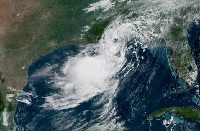
Tropical storm Bertha made landfall on the Gulf Coast. If you are anywhere between the Florida Panhandle and the Texas coast, you may be refreshing the radar at this moment. Bertha made landfall in St. Bernard Parish on Louisiana’s coast Wednesday afternoon. It continues to bring heavy rainfall, storm surges, and flash flooding risk along the northern Gulf Coast, as it moves westward towards Texas.
Here is the latest information on Tropical Storm Bertha, including its current location, strength, direction, and what you can expect if your area is in its path.
Note that storm tracks and intensities can change quickly. Check the National Hurricane Center for the latest advisories rather than relying solely on a single article.
Where is Tropical Storm Bertha?
Around 2 p.m. Wednesday CDT, Bertha’s core made landfall in the eastern part of St. Bernard Parish (Louisiana), near the Biloxi wildlife management area. The storm moved westward after landfall. It passed over New Orleans overnight and Thursday before moving on to the upper Texas Coast.
Forecasters have described Bertha as a “lopsided system”, meaning that most of the heaviest rainfall and strongest winds were concentrated south and offshore from its center. This has made it difficult to predict its path, and the storm’s heart briefly re-formed further south along the Louisiana coastline.
The wind speed and strength of Tropical Storm Bertha
Bertha was named the second storm of the 2026 Atlantic Hurricane Season after it formed from Tropical Depression Two. Hurricane Hunter aircraft measured sustained winds of forty mph during formation. By Tuesday evening, the storm reached a maximum of sustained winds before it began a slow fading trend. According to the latest advisory, the maximum sustained winds are estimated at 45 mph with tropical storm-force winds reaching more than 100 miles out from the center.
Forecast Path of Tropical Storm Bertha
According to the National Hurricane Center, Bertha is expected:
- Keep close to the shore as you continue tracking along the northern Gulf Coast.
- On Wednesday night and Thursday, move through southern Louisiana near the New Orleans metropolitan area.
- Arrive at the upper Texas Coast on Thursday afternoon or evening
- A tropical depression will be weakened on Thursday
- As it moves into Texas, it could dissipate by Friday night or late Thursday.
Forecasters noted that the storm was moving slowly and “crawling Westward with Little Acceleration,” which may be part of the reason why flooding and rainfall risks are still high even though wind speeds have decreased.
Current Warnings and Watches
From the Alabama/Florida border westward to Cameron, Louisiana – which includes the Metro New Orleans Area and Lake Pontchartrain – a Tropical Storm Warning has been issued. A Coastal Flood Warning also exists for the Mississippi and Louisiana coasts, where moderate coastal flooding can be expected.
As a precaution, beaches have been closed in Florida and Mississippi. Officials warn of dangerous rip currents and rough conditions on Gulf Coast beaches throughout the week, even where the weather may appear calm.
What Impacts to Expect
Flash Floods and Rainfall
Bertha will produce between 1 and 4 inches of rainfall with isolated totals as high as 6 inches across a region stretching from southwest Florida to southern Texas on Thursday or Friday. Forecasters have warned that this rainfall may cause flash flooding in urban areas.
Storm Surge
Storm surges of up to 3 feet are possible between the Alabama-Florida Border and Port Bolivar in Texas. Similar levels may also be possible around Lake Pontchartrain, Louisiana. The combination of this surge and normal tides could cause areas that are normally dry to flood near the coast.
Tornado Risk
The forecasters haven’t completely ruled out the possibility of a few tropical storms and waterspouts on the northern Gulf Coast when Bertha passes through.
Louisiana’s Preparedness for
Louisiana Governor Jeff Landry confirmed state and local officials started preparations early, working with the Sewerage and Water Board of New Orleans. About 30,000 sandbags have been distributed in Orleans Parish, and 90% of drainage pumps are operational.
How Bertha fits into the 2026 hurricane season
Bertha, the second named hurricane for the 2026 Atlantic Hurricane season, arrives just weeks after Tropical Storm Arthur made landfall on the Texas Gulf Coast. Bertha was the first official storm to land in the US this season.
Frequently asked questions
Where was Tropical Storm Bertha’s landfall?
Bertha landed in St. Bernard Parish (Louisiana) near the Biloxi Wildlife Management Area around 2 pm CDT on Wednesday.
What is the current wind speed of Tropical Storm Bertha?
Bertha reached a peak of sustained winds at 60 mph before fading. Recent advisories place sustained winds at around 45 mph.
Does New Orleans have a tropical storm alert?
A Tropical Storm Warning is in effect for the Metro New Orleans and Lake Pontchartrain area.
When will Tropical Storm Bertha be over?
Bertha will likely weaken into a tropical storm by Thursday, and then dissipate to become a post-tropical storm by Friday night or late Thursday.
Will Bertha affect Texas?
Tropical storm conditions could be possible along the upper Texas coastline by Thursday. The storm is expected to move inland, where it will dissipate.
How many raindrops is Bertha predicted to bring?
Forecasters predict 1 to 4 inches in general, but isolated areas could see up to 6 inches. This increases the risk of flash flooding, especially in cities.
Final Thoughts
Tropical Storm Bertha is moving slowly westward along the Gulf Coast. It will bring flooding rains, storm surges, and rip-current risks, even as the wind speed gradually decreases. Stay informed by following local emergency instructions and official National Hurricane Center advisory messages if you are in the path of the storm. USA Times Square will provide you with updates on Bertha’s progress.